
|
TelemetryPro® Flight Data Analyzer
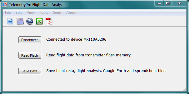
Flight Data Analyzer is a software program used to download and analyze the flight data recorded by either the transmitter or the receiver. The data is presented in various plots and as a Google Earth trajectory. An Excel spreadsheet is also created to allow the user to perform any further analysis that might be needed. It can also replay the Kate audio. It can also display an animated 3D view that shows the rocket orientation during the entire flight.
Some example flight data files are included for anyone wishing to test drive this software. Just go to the File menu and open one of the example files. |

Download
|
Flight Data Analyzer (Rev 4.9) Only windows is supported at this time.
Last update: June 30, 2024 Download the software package and save it to your local hard drive. Then run it. Note: Depending on your browser, you may have to right click the download icon and then select "Save as..."
Version 4.9 is the latest version. It supports the original Kate-1 and also the new Kate-2 and Kate-3. It works on Windows 7, 8, 10 and 11. It is not supported on Windows-XP. Some functionality may still run on Windows-XP but there are no guarantees and the 3D viewer definitely will not work on XP. More details about version 4.9 can be found here. The installation process for this software does not make any changes to the Windows system or to the registry. It simply creates a folder named "TelemetryPro" in your "Documents" directory. It also puts a shortcut to the program on your desktop. To uninstall the program just delete the TelemetryPro folder and the shortcut. |
|
Google Earth Trajectory
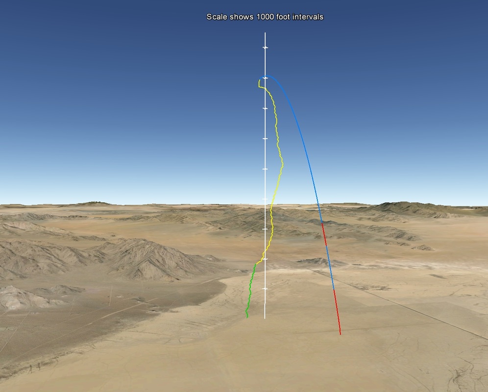
Flight Data Analyzer automatically generates a flight trajectory that can be viewed in Google Earth. This image shows a two-stage flight made at Lucerne Dry Lake in California. The motor burn for each stage is shown in red. Blue indicates coasting. Yellow shows descent on drogue parachute and green is on the main parachute. Click on the image for a closer look.

Download
Download the Google Earth file and you will be able to view the trajectory from any angle. It gives a very good virtual 3D view of the flight.
Note: You will need to have Google Earth installed on your computer to view the file. |
|
|
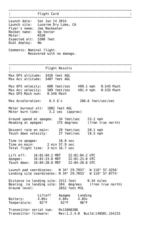
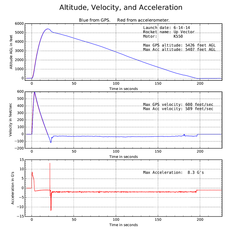
Flight Summary Report
Flight Data Analyzer also generates a flight summary report in PDF format. The report contains a summary page of all the key data and then seven pages of plots. You can view an example using this download button.

Example Flight Summary Report
|
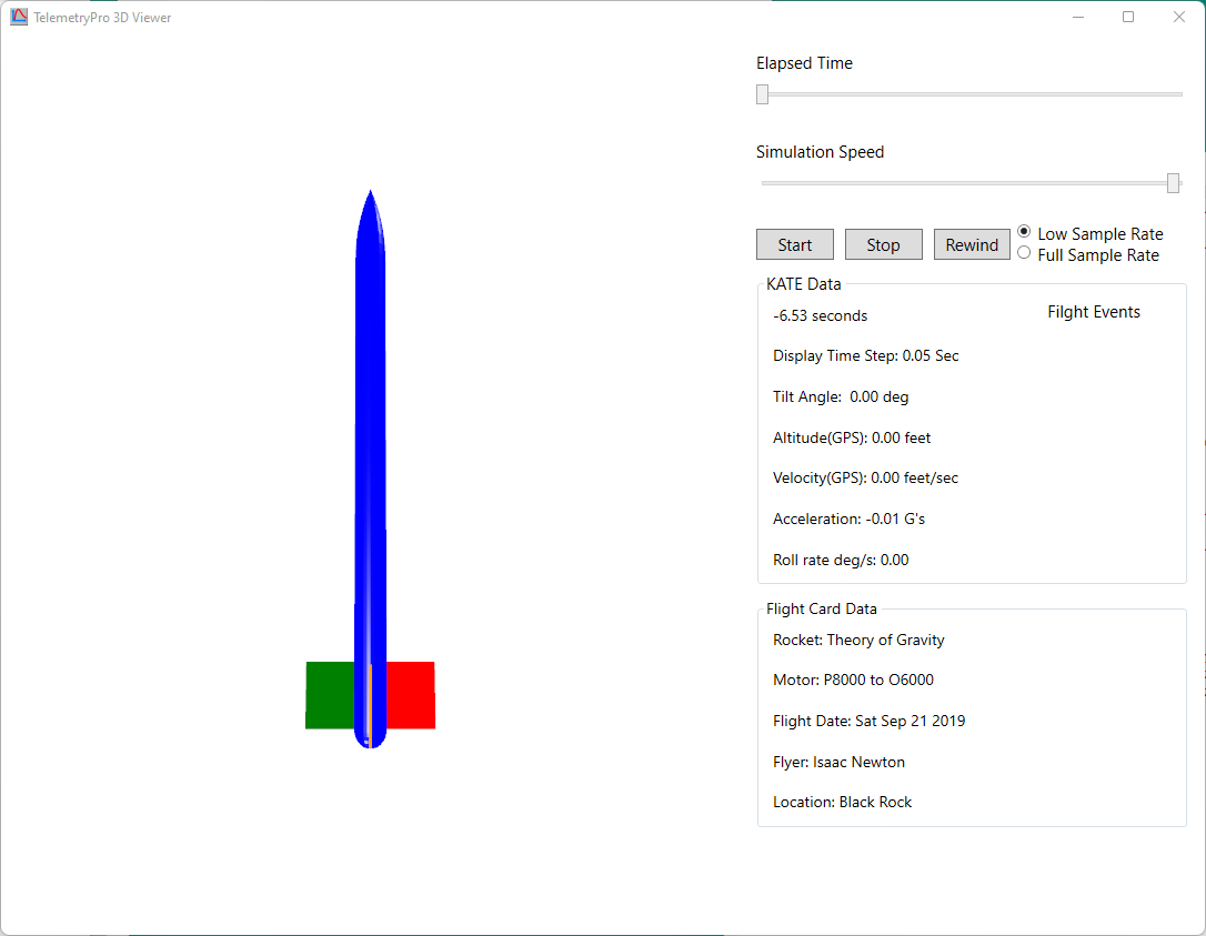
3D Viewer
The Flight Data Analyzer can display an animated 3D view of the rocket orientation for an entire flight. It does this using 3-axis gyro data that is recorded during a flight by a Kate-2 or Kate-3 transmitter. A user just needs to download the flight data that was recorded onboard their transmitter and then press the 3D Viewer icon to see the flight animation.
A screen shot of the 3D Viewer playback window is shown below. There is an animated model of the rocket that will show the orientation as the flight progressed. It also displays key flight data such as time, altitude, velocity, acceleration, roll rate and tilt that are synchronized with the animation. It also indicates when important flight events occur, such as when the motor is burning, when apogee is reached and when main parachute deployment occurs. The user can control the speed at which it plays and even run it forward and backwards as needed to study any point in time during the flight.
A screen shot of the 3D Viewer playback window is shown below. There is an animated model of the rocket that will show the orientation as the flight progressed. It also displays key flight data such as time, altitude, velocity, acceleration, roll rate and tilt that are synchronized with the animation. It also indicates when important flight events occur, such as when the motor is burning, when apogee is reached and when main parachute deployment occurs. The user can control the speed at which it plays and even run it forward and backwards as needed to study any point in time during the flight.
|
|
This short video demonstrates the 3D viewer in action. It shows an actual two-stage flight to 142,000 feet. It shows how the rocket behaved during each motor burn and subsequent coast phases. This rocket started coning after sustainer motor burnout at about 40,000 feet. The coning grew progressively worse and eventually the rocket started tumbling at about 120,000 feet as it was still coasting to apogee in very thin air. At apogee, there is a sudden jerk visible in the animation that was due to the recovery system being deployed. However, the animation is not sophisticated enough to show a parachute deployment.
The 3D viewer can show the entire flight all the way to landing but in order to keep this video short, the descent phase has been omitted here. Most of the descent phase is just random tumbling anyway. |
There is no audio in this video but the cursor will help call your attention to some interesting data being displayed at different points in time.
Anyone wishing to try it out can download the Flight Data Analyzer, go to the File menu and open the example file for the two-stage 142K flight.
The 3D Viewer software was written by Greg Spohn. It is integrated into the Multitronix Flight Data Analyzer.
Anyone wishing to try it out can download the Flight Data Analyzer, go to the File menu and open the example file for the two-stage 142K flight.
The 3D Viewer software was written by Greg Spohn. It is integrated into the Multitronix Flight Data Analyzer.
|
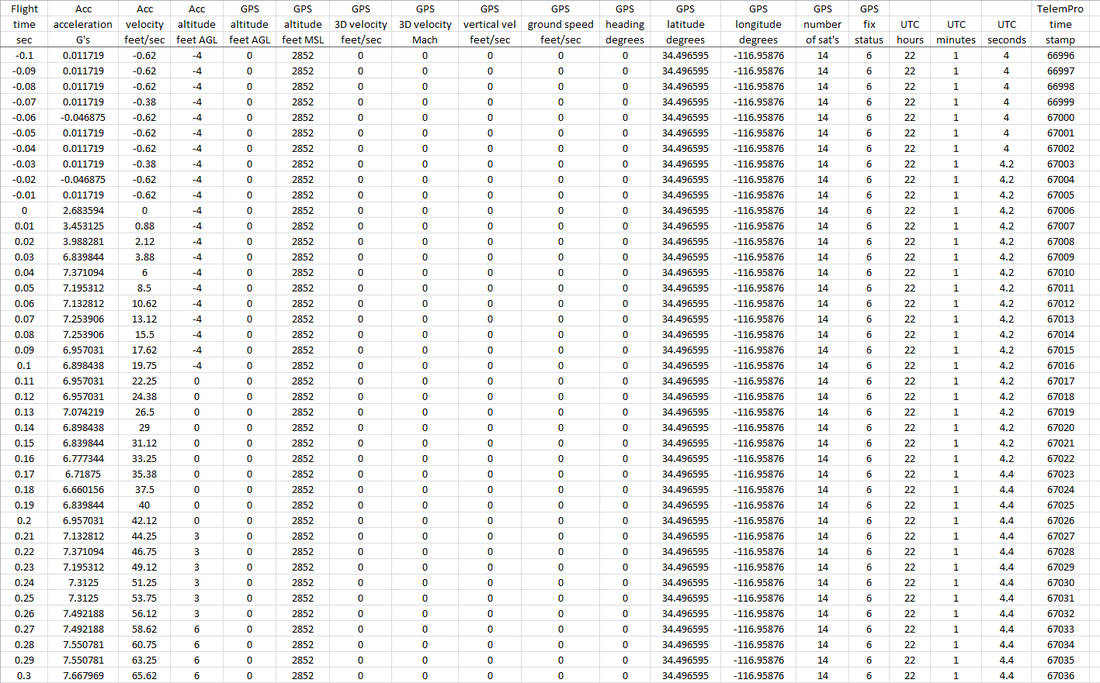
Excel Spreadsheet
Flight Data Analyzer automatically generates a spreadsheet with all the data in CSV format. This can be opened in Excel or most any other spreadsheet program. It allows the user to perform whatever additional analysis is desired. Including creating custom plots.

Example CSV Spreadsheet

Example Excel Spreadsheet
|